
· 3 min read
Kieran Farr

At the recent Caltrans EAC meeting a host of agency professionals, community leaders and technology experts like 3DStreet’s own Kieran Farr shared expertise on the global trend of community-led planning and the current blockers preventing local stakeholders from engaging with local transportation agencies. Below is a summarization of the presentation to share our learnings from practitioners around the world experimenting with community-led design.

· 7 min read
Kieran Farr

"Geospatial" is the uniting theme for the many feature requests we get from 3DStreet's growing user base. Users can already place custom street scenes, so it's natural to understand why geospatial features like 3D Google Map Tiles or Augmented Reality visualization keep coming up in conversations with users when we explore common repeatable workflows for visualizing safer infrastructure.

To kick off 2024 we've been doing some experiments to see how these technologies could be applied to public streets and spatial design.

Proof of concept 3D Tiles and 3DStreet scene combined.

· 5 min read
Marc Schlossberg

Greetings! I'm Marc Schlossberg, and I've been working alongside Danny Pimentel and graduate student Luke Walker at the University of Oregon on an exciting project: crafting augmented reality (AR) landscapes for our streets. What I have here is a practical, step-by-step guide designed to walk you through how to bring this innovative vision to your own neighborhood. So, let's roll up our sleeves and get our hands digitally dirty!

· 3 min read
Ivan Denysyuk
Kieran Farr

2023 marks a significant year for 3DStreet, made possible through our talented community of contributors both volunteer and paid. Zade Agency fits in the latter category as a software development team for-hire based in Ukraine. Over the past year Zade emerged as a major boost to our development productivity and I wanted to share how their contributions have helped 3DStreet in a critical time for the organization.

· 5 min read
Kieran Farr

A few weeks ago I attended a "developer day" at a local electronics company down the road featuring their new mixed reality VR headset. I spent the entire day testing many different WebXR applications with a heavy focus on evaluating which user interaction elements will be relevant for developers.

Below are some notes intended for other 3DStreet code contributors to reference as we work on supporting new WebXR compatible devices.

· 7 min read
Kieran Farr
Arthur Mougin

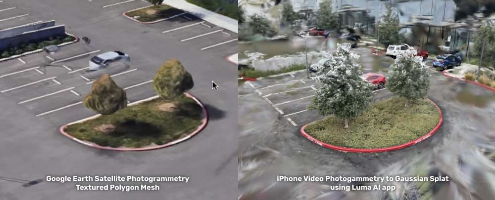
3DStreet's mission is to empower anyone to visualize safer streets. A common request to support this mission is to bring in local real-life elements from your actual streets by scanning them into 3D objects. Until now, the best technology for doing this (photogrammetry to textured 3D polygons) resulted in huge file sizes, difficult to edit output files, and gooey visuals like melting trees or cars that you may see on Google Maps in 3D mode.

Enter Gaussian Splatting -- earlier this year a groundbreaking photogrammetry and visualization technique called gaussian splatting was released as part of a research paper published at SIGGRAPH 2023. I believe splatting to be the best modern method to allow everyday users like you and me to scan 3D objects with our phones and retain the fine detail of organic material especially plants, trees, flowers and other natural elements -- all things we'd like to see more of in our streets!

Side by side picture of the same apple tree showing 3d mesh vs. gaussian splat photogrammetry techniques

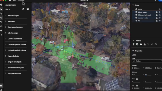
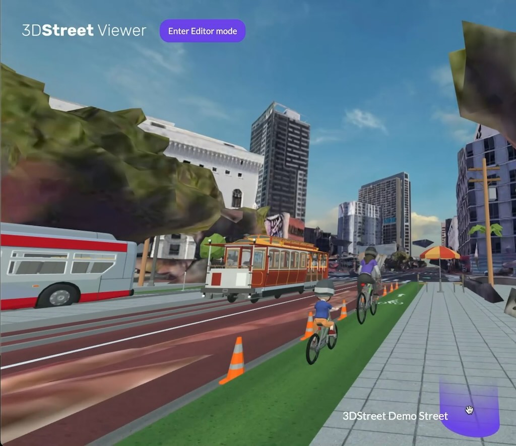
This is still an R&D project, not yet a supported built-in feature of 3DStreet. In this post we share research and progress on how we are improving the visual appearance of compositing new scenes from multiple splats using depth buffer and selective splat discarding in three.js and A-Frame, underlying 3D frameworks supporting 3DStreet.